A Wind Voyage itinerary is planned around the wind, not in spite of it. Each route is a voyage — ocean miles, landfalls, and the adventures in between — and the leg-by-leg wind picture is the honest measure of the yacht.
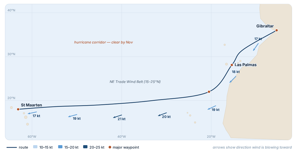
Every passage below carries its climatological wind picture, leg by leg. Where the wind is on the beam or aft, the wings do the work and the engines stay silent — that is what the wind-power figure on each voyage measures. The numbers are indicative, drawn from US Pilot Charts and the COGOW dataset; the seamanship behind them is not.
"No ocean, no life. No blue, no green. No ocean, no us."
And never out of touch. With Starlink aboard, you can run a business, join the call, and stay close to family from any anchorage on earth — the isolation of a sea voyage is entirely optional.
North Atlantic · November
The Atlantic Crossing
Gibraltar to St Maarten — the classic trade-wind passage, dropped south to the breeze and reached across to the Caribbean season.
"The ocean gives us oxygen, food, climate stability — and we treat it like an afterthought. We can't."
Broad reach south. Watch for late-Atlantic lows tracking under the Azores High.
Leg 2
Las Palmas → 22°N
~250 nm · ~1 day
Wind: NE 15–22 kt
Sea: 2.0–2.5 m
Drop south to the trade-wind belt. Wings deployed; first big sailing leg.
Leg 3
Trade-wind reach
~2,200 nm · 7–9 days
Wind: ENE 18–22 kt
Sea: 2.5–3.5 m, long swell
Beam to broad reach — best wing performance. Night squalls 30–35 kt; auto-reef.
Leg 4
Approach St Maarten
~300 nm · ~1 day
Wind: E 15–20 kt
Sea: 2.0–2.5 m
Beam reach. Reef early — landfall traffic and a daylight arrival.
Aboard this voyageWhale and dolphin passages off the African shelf · a Canary Islands layover under Teide · open-ocean nights under wing · arrival into the Caribbean charter season.
Wind data: November climatological averages from US Pilot Charts and the COGOW dataset. The North Equatorial Current adds approximately 0.3–0.5 kt of west-set through the trade-wind belt. Distances are routed (not great-circle) for the recommended drop-south-then-west pattern. Total approximately 3,450 nm; 13–15 day passage at a 12 kt average.
South Pacific · January
Panama To Tahiti
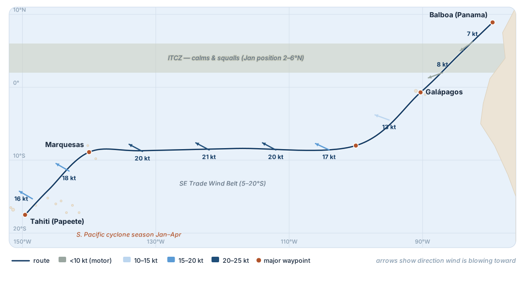
Through the doldrums and into the great SE trade-wind belt — the longest, finest reaching passage in the world, by way of the Galápagos and the Marquesas.
"The sea is my memory. Memories fade, but it remains, unchanging."
Mostly motor or motor-sail through the Panama Bight and ITCZ. SE trades fill in approaching the equator.
Leg 2
Galápagos → 8°S
~600 nm · ~3 days
Wind: SE 12–18 kt
Sea: 1.5–2.5 m
Drop south under the ITCZ to lock into established trades. First serious sailing leg; wings deploy.
Leg 3
8°S → Marquesas
~2,400 nm · 11–13 days
Wind: SE 18–22 kt
Sea: 2.5–3.5 m, long swell
The big reach. Broad reach at TWA 130–140°. South Equatorial Current adds 0.5–0.8 kt of west-set.
Leg 4
Marquesas → Tahiti
~750 nm · ~4 days
Wind: E/SE 15–20 kt
Sea: 2.0–3.0 m
Beam reach via the Tuamotus. Atoll passes require slack-water timing and good light. Daylight arrival Tahiti.
Aboard this voyageGalápagos wildlife under permit · the soaring landfalls of the Marquesas · Tuamotu atoll diving and lagoon anchorages · the Society Islands.
Wind data: January climatological averages from US Pilot Charts and the COGOW dataset. ITCZ position in January typically 2–6°N; expect 12–24 hours of light/variable in the doldrums band. The South Equatorial Current adds 0.5–1.0 kt of favourable west-set through the trade belt. Total approximately 4,650 nm including stops; 22–25 days at a 12 kt average. Cyclone-hole options on arrival: Marina Taina (Tahiti), Apooiti (Raiatea), or repositioning south to the Australs.
Southern Ocean · Austral Summer
Cape Horn To South Georgia
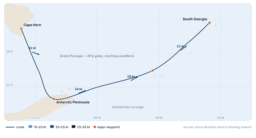
Across the Drake under reefed wings to the Antarctic Peninsula, then a reaching passage up the Scotia Sea to the greatest wildlife coast on earth.
"Beauty is the salve that allows us to keep working for what we love."
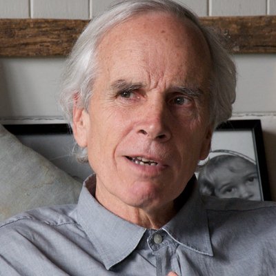
Doug Tompkins · co-founder, The North Face & Esprit · Tompkins Conservation — returned 2.2 million acres of Patagonia and Tierra del Fuego to public landLearn more about Doug Tompkins’s ocean exploits →
~1,750
Nautical Miles
12–16
Days
≈ 80%
Under Wind Power
20–35 kt
Westerly Average
Leg 1
Cape Horn → Peninsula
~500 nm · 2–3 days
Wind: W/NW 25–35 kt
Sea: 4–6 m
Downwind across the Drake under deeply reefed wings. The platform's motion and autonomy turn the most feared crossing into a fast reach.
Leg 2
Peninsula cruising
~250 nm · 4–6 days
Wind: variable 10–25 kt
Katabatic gusts
Ice navigation under power and sail through the Gerlache and Lemaire. Kayaking, polar diving, ski-mountaineering from the deck.
Leg 3
Scotia Sea reach
~600 nm · 3–4 days
Wind: W 20–30 kt
Sea: 3–5 m
Broad reach northeast across the Scotia Sea on the prevailing westerlies — fast, free miles in the roaring latitudes.
Leg 4
Approach South Georgia
~400 nm · ~2 days
Wind: WNW 18–28 kt
Sea: 2.5–4 m
Reaching approach to Shackleton's island and its harbours of king penguins, elephant and fur seals.
Aboard this voyagePolar diving · ski-mountaineering from the anchorage · penguin and seal colonies · kayaking among bergs · Shackleton's South Georgia and the heroic-age harbours.
Wind data: austral-summer (Dec–Feb) climatological averages from US Pilot Charts and the COGOW dataset. The Drake Passage is a downwind/reaching crossing on the prevailing westerlies in this direction; routing is weather-window dependent and undertaken with ice-class capability and an expedition ice pilot. Distances and durations are indicative and include Peninsula cruising days.
High Arctic · Summer Solstice
Greenland, Iceland & Svalbard
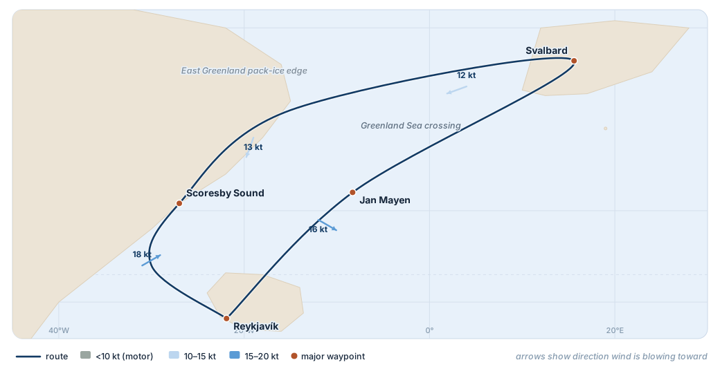
North on the Atlantic westerlies to the land of the midnight sun — a circuit of the great ice, from Iceland to Scoresby Sound, Spitsbergen and lonely Jan Mayen.
Reach across the Denmark Strait to the largest fjord system on earth. Watch the ice charts.
Leg 2
NE Greenland coast
~450 nm · 3–4 days
Wind: N variable 10–20 kt
Pack-ice edge
Ice navigation along the pack edge under power and sail; landings among the bergs.
Leg 3
Greenland → Svalbard
~600 nm · 3 days
Wind: NE 12–20 kt
Sea: 2–3 m
Open crossing of the Greenland Sea to Spitsbergen — polar-bear coast and tidewater glaciers.
Leg 4
Svalbard → Jan Mayen → Iceland
~700 nm · 4–5 days
Wind: variable 10–22 kt
Closing the loop
South past lonely Jan Mayen and its volcano, closing the circuit back at Iceland.
Aboard this voyagePolar-bear coastlines · tidewater glaciers and calving fronts · the midnight sun · seabird cliffs · Scoresby Sound, the largest fjord system on earth.
Wind data: June–August climatological averages (US Pilot Charts / COGOW). High-latitude summer winds are variable and often light, and a meaningful share of the voyage is ice navigation under power — hence the lower wind-power figure. All routing is ice-chart and weather-window dependent. Distances are indicative and include cruising days.
Atlantic Tropics · Winter Trades
The Caribbean & Bahamas
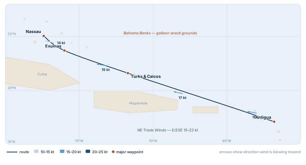
Effortless trade-wind cruising with the breeze on the beam — from the Lesser Antilles up through the Turks and onto the Bahama Banks, over the galleon grounds.
Beam reach down the island chain in classic Antilles trade wind.
Leg 2
Virgin Is → Turks & Caicos
~400 nm · 2 days
Wind: ESE 15–22 kt
Sea: 1.5–2.5 m
Open reach along the north coast of the Greater Antilles.
Leg 3
Turks → Exumas
~450 nm · 2–3 days
Wind: E 12–20 kt
Onto the Banks
Gin-clear water, blue holes, and the historic galleon wreck grounds of the Bahama Banks.
Leg 4
Exumas → Nassau
~150 nm · ~1 day
Wind: E 12–18 kt
Sea: 1–2 m
Short hops through the cays to a daylight arrival.
Aboard this voyageGalleon and reef wreck diving on the Banks · blue holes · empty cays and beaches · the game-fishing and diving of the Gulf Stream.
Wind data: December–April climatological averages (US Pilot Charts / COGOW). The NE trades are among the most reliable wind on earth — the textbook beam-reach cruising ground. Distances are routed island-to-island; roughly 1,200 nm at a relaxed pace.
Oceania · Trade-Wind Season
Polynesia, Fiji & The Reef
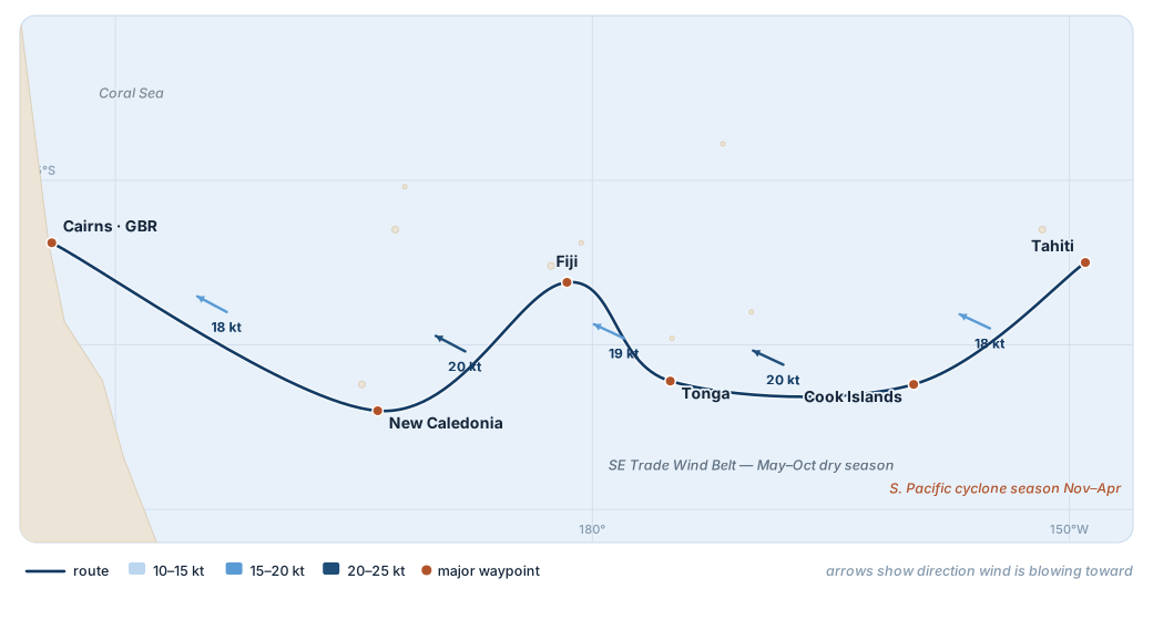
Westbound across the South Pacific on the SE trades — high islands, atolls and the Great Barrier Reef, from Tahiti to the Coral Sea.
"We're all deeply connected — not only to each other, but to the ocean and the planet as well."
Broad reach west from the Societies into the heart of Polynesia.
Leg 2
Cook Islands → Tonga
~700 nm · 3–4 days
Wind: SE 18–22 kt
Sea: 2–3 m
Trade-wind reach across the dateline to the Kingdom of Tonga.
Leg 3
Tonga → Fiji
~450 nm · 2 days
Wind: SE 15–20 kt
Lau Group
Island-hop to Fiji's reef-fringed anchorages and the Lau Group.
Leg 4
Fiji → New Caledonia → Cairns
~1,750 nm · 9–11 days
Wind: SE/E 15–22 kt
Sea: 2–3.5 m
The long reach across the Coral Sea to the Great Barrier Reef.
Aboard this voyageAtoll diving and lagoon anchorages · the Great Barrier Reef · humpback whales in the Tongan winter · remote island cultures · reef passes timed to the light.
Wind data: May–October dry-season averages (US Pilot Charts / COGOW) — the cyclone-free window for the South Pacific. The SE trades give long, steady beam-to-broad reaching. Total approximately 3,500 nm including island stops.
Southeast Asia · The Coral Triangle
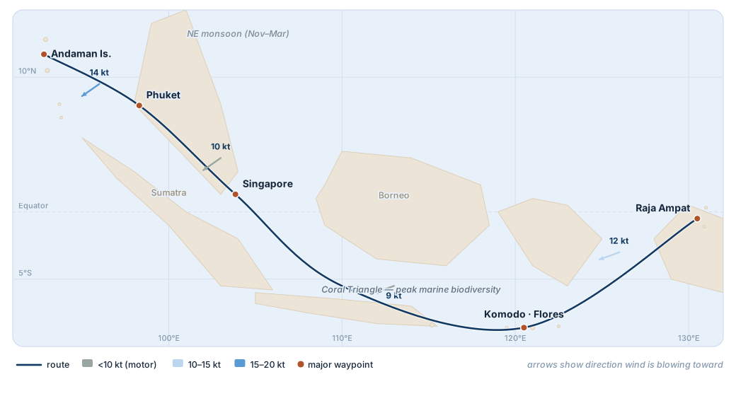
Raja Ampat & The Andamans
West through the Indonesian archipelago and up the Andaman Sea — the richest marine biodiversity on the planet, monsoon-routed through ten thousand islands.
"The deep ocean is the last frontier on the planet we can still actually go to."
Through the epicentre of coral diversity — manta and reef diving among the islands.
Leg 2
Komodo → Bali → Java Sea
~700 nm · 4 days
Wind: light SE / var
Lesser Sundas
Past the dragons of Komodo and west along the Lesser Sundas.
Leg 3
Java Sea → Singapore
~750 nm · 4–5 days
Wind: light, motor-sail
Karimata Strait
Across the equator and up to the crossroads of Asia.
Leg 4
Singapore → Phuket → Andamans
~1,100 nm · 6–7 days
Wind: NE monsoon 12–18 kt
Malacca Strait
Up the strait and out to the 300 islands of the Andaman Sea.
Aboard this voyageCoral Triangle and manta diving · Komodo dragons · liveaboard reef exploration · the near-empty outer islands of the Andaman Sea.
Wind data: NE-monsoon (Nov–Mar) climatological averages (US Pilot Charts / COGOW). Winds within the archipelago are light and variable, so much of this voyage is motor-sailing between dive grounds — the wind-power figure reflects that honestly. Routing avoids the SW-monsoon wet season.
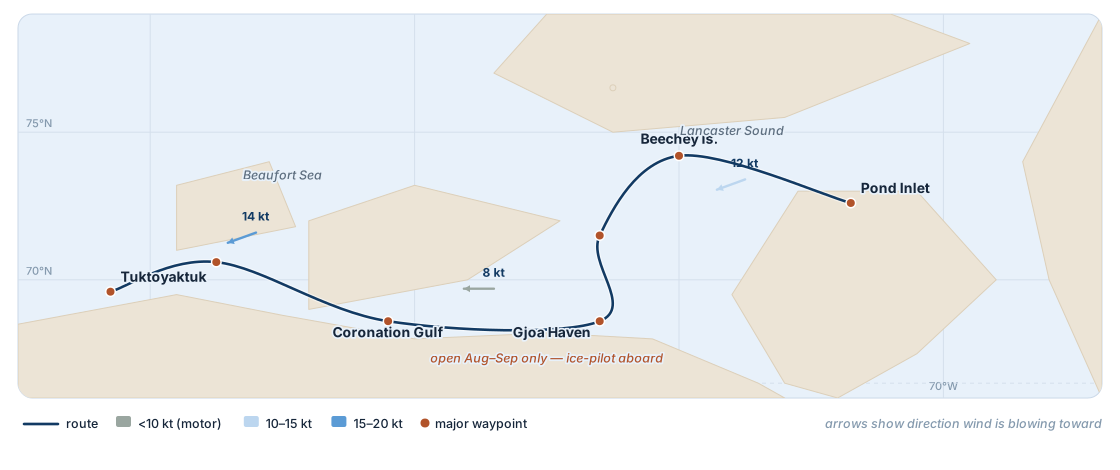
Arctic Canada · August–September
The Northwest Passage
Pond Inlet to the Beaufort Sea — the legendary transit through the Canadian Arctic, a navigation defined by ice, autonomy, and a serious expedition platform.
"The oceans are 70 percent of our entire planet — and 95 percent of that is unexplored."
Through historic Lancaster Sound to Franklin's wintering ground at Beechey Island.
Leg 2
Beechey → Gjoa Haven
~350 nm · 3–5 days
Wind: variable, ice-led
Peel Sound — the crux
Ice navigation down Peel Sound. Amundsen wintered at Gjoa Haven, which bears his ship's name.
Leg 3
Gjoa Haven → Coronation Gulf
~300 nm · 2–3 days
Wind: light / variable
Queen Maud Gulf
Shoal, intricate waters under power and sail, threading the shallow gulf.
Leg 4
Coronation Gulf → Tuktoyaktuk
~350 nm · 2–3 days
Wind: W 12–20 kt
Amundsen Gulf
Out through Amundsen Gulf into the open Beaufort Sea.
Aboard this voyageFranklin and Amundsen history · Inuit communities · narwhal, beluga and polar bear · 24-hour Arctic light · the ultimate test of autonomy and ice-capability.
Wind data and timing: the passage is navigable in the August–September melt window only, and routing is entirely ice-chart dependent, undertaken with ice-class capability and an ice pilot aboard. The low wind-power figure is honest — this is a transit defined by ice, not breeze.
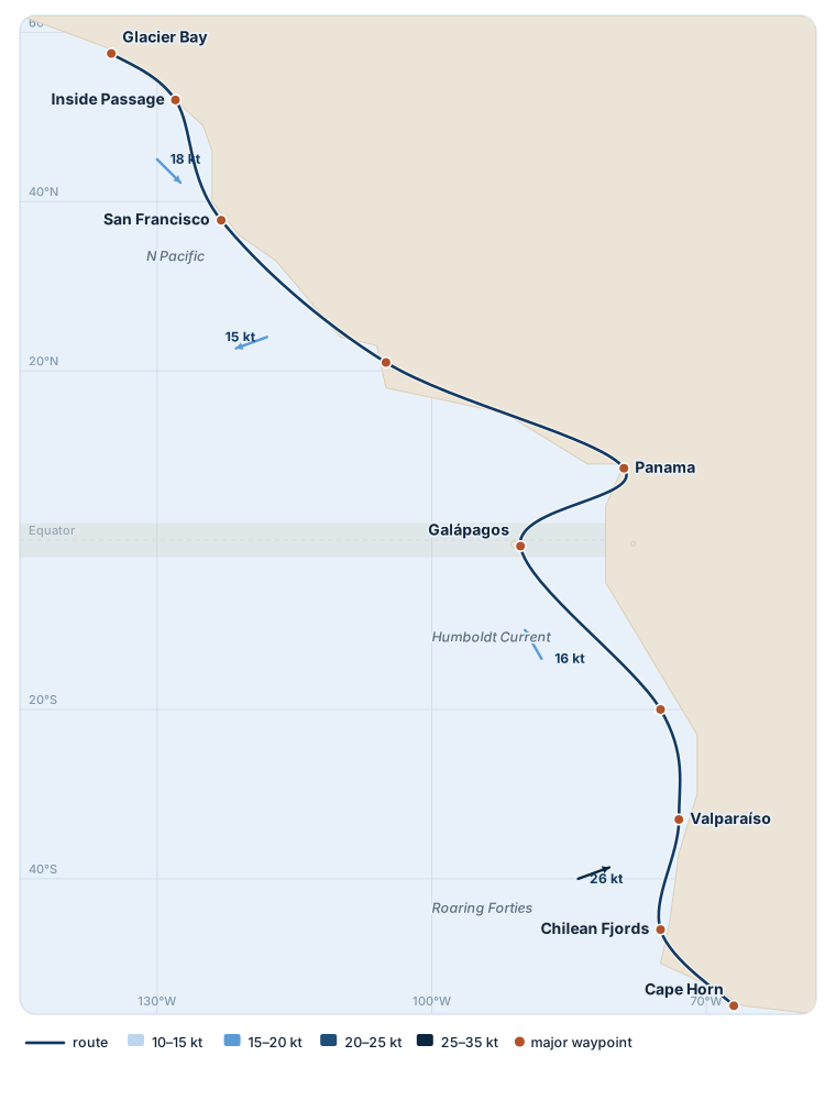
The Americas · Pacific Coast
Alaska To Patagonia
Pole to pole down the Pacific coast of the Americas — the Inside Passage, the doldrums and the Humboldt, to the fjords of Chile and Cape Horn.
"Without a healthy environment there are no shareholders, no employees, no customers, and no business."
Yvon Chouinard · founder, Patagonia · lifelong fly-fisherman of the Pacific Northwest and Patagonian rivers · gave the company to fund climate & ocean conservation, 2022Learn more about Yvon Chouinard’s ocean exploits →
~9,500
Nautical Miles
Season-long
Multi-Month
≈ 65%
Under Wind Power
60°N–56°S
Latitude Span
Leg 1
Glacier Bay → San Francisco
~1,500 nm
Wind: NW 15–25 kt
Inside Passage
Down the glacier-carved Inside Passage and the North Pacific coast on the summer northwesterlies.
Leg 2
San Francisco → Panama
~3,300 nm
Wind: N/NW → NE trades
Sea: 1.5–3 m
Offshore reaching down the Mexican and Central American coast.
Leg 3
Panama → Galápagos → Callao
~1,900 nm
Wind: light → SE trades
Humboldt Current
Across the doldrums to the Galápagos, then south into the cool Humboldt.
Leg 4
Callao → Cape Horn
~2,800 nm
Wind: SE → W 25–40 kt
Roaring Forties
South through the Chilean fjords to the Beagle Channel and Cape Horn.
Aboard this voyageGlaciers and whales of SE Alaska · the Inside Passage · Galápagos wildlife · a thousand miles of Chilean fjords · rounding Cape Horn under sail.
A pole-to-pole coastal odyssey best run with the seasons; figures are indicative. The Patagonian and Cape Horn legs are weather-window dependent and undertaken with full expedition capability.
Mediterranean · Summer Season
The Western Med & Aegean
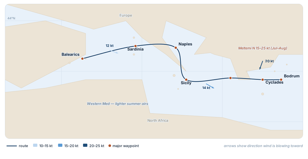
The family season — the Balearics to the Turkish coast on the summer Meltemi, when the priority is the bay, not the passage.
"Sailing is the most beautiful way to look at the world."
An easy reach across the western basin from the Balearic anchorages.
Leg 2
Sardinia → Naples → Sicily
~350 nm
Wind: variable
Tyrrhenian Sea
Down the Tyrrhenian past the Amalfi coast and the Aeolian volcanoes.
Leg 3
Sicily → Ionian → Cyclades
~450 nm
Wind: building E/N
Sea: 1.5–2.5 m
East across the Ionian into the heart of the Aegean.
Leg 4
Cyclades → Bodrum
~200 nm
Wind: Meltemi N 15–25 kt
Gusting more
Island-hopping the Cyclades on the summer Meltemi to the Turquoise Coast.
Aboard this voyageThe bays of the western Med · Aeolian volcanoes · Greek island anchorages · a Blue Cruise on the Turkish coast · the weeks when the family is together.
Wind data: May–October season. The Aegean Meltemi (N 15–25 kt, gusting harder) dominates July–August, while the western basin runs lighter. Distances are cruising estimates, not deliveries.
The Capstone · 150–200 Days
The Global Odyssey
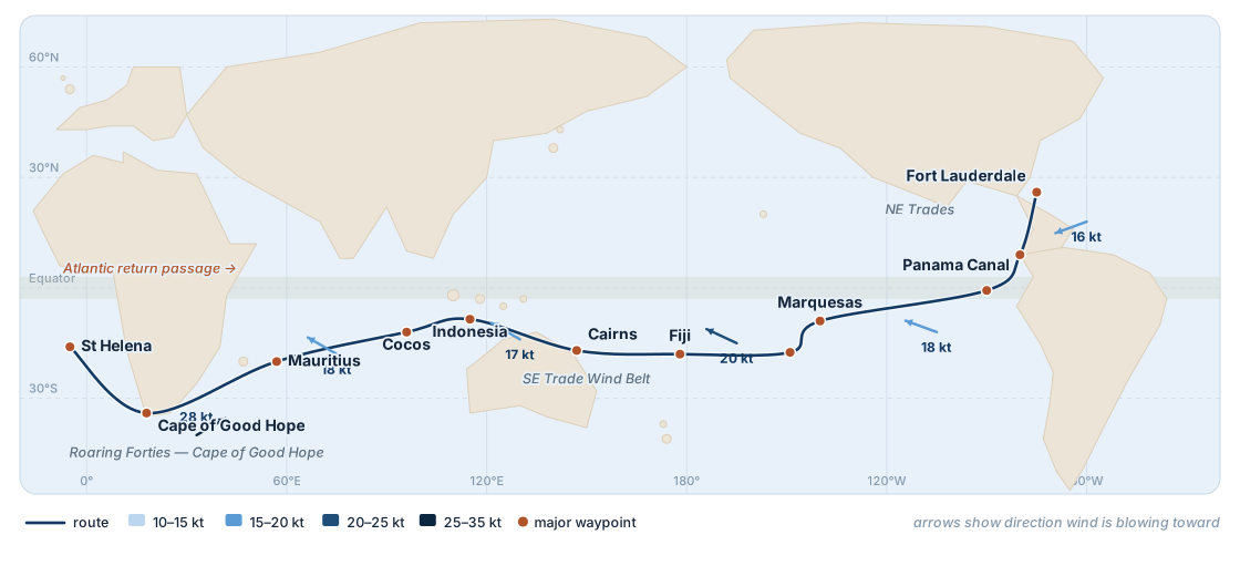
A circumnavigation routed season by season around the trade winds and the great capes — six continents under wind power, on a single voyage. Every itinerary on this page, strung into one.
"I want to inspire the next generation of explorers — the kids who look at the ocean and think 'what's down there?'"
Down through the Caribbean and the Canal, then the great trade-wind reach to Polynesia.
Leg 2
South Pacific
Marquesas · Fiji · the Reef
Wind: SE trades
Island-hopping west across the South Pacific in the dry-season trades.
Leg 3
Indian Ocean
Indonesia · Mauritius · the Cape
Wind: SE trades → Agulhas
The Indian Ocean trades to the Mascarenes and around the Cape of Good Hope.
Leg 4
Atlantic Return
Cape Town · St Helena · home
Wind: SE → NE trades
The St Helena trades north and the Atlantic crossing back to the Americas.
The ultimate voyageThe polar option, the equatorial atolls, the great capes — the fullest expression of what a wind-powered explorer is built to do.
Indicative routing for a west-about, trade-wind circumnavigation of roughly 28,000 nm. Seasonal timing is planned to avoid the cyclone season in each ocean. The wind-power share reflects long trade-wind reaches, broken by canal transits and equatorial calms.
Begin Your Voyage
Plan A Route
Routing studies, weather-window planning, and full leg-by-leg wind maps are part of the project package provided to qualified principals.
"Pioneering spirit should continue — not to conquer the planet or space, but rather to improve the quality of life."